Romania’s Maritime Hydrographic Directorate published a new radio navigational warning on Tuesday that Sunday’s dedicated Khoryv keep-clear no longer has the right position. The official English text, printed on the Directorate’s avize-radio page as ARN 158/2026 and cancelling ARN 156/2026, states that at 10:00 UTC on 27 October — 12:00 local — the partially sunken vessel M/V Khoryv was reported in position 43-49.50 N, 028-53.37 E. The header of the same notice repeats the plot to a thousandth of a minute as 43-49.502 N, 028-53.368 E. The vessel remains afloat, capsized. Three crew members are reported missing. All ships in the vicinity, and all ships transiting the area, are requested to keep a sharp lookout. Mariners are advised to keep a safe distance of at least one nautical mile from the vessel. It is a danger to navigation. Relevant information is to be reported to MRCC Constanta on VHF Channel 16 or by e-mail to [email protected]. The Romanian page, ARN 158/2026, prints the same geometry, the same 12:00 local clock and the same three-missing line. Industry coastal reprints carry the notice as 158/26, active until further notice.
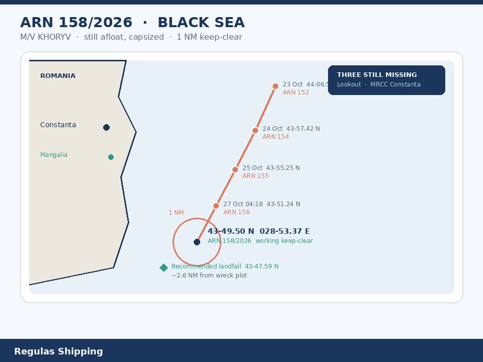
That is the working primary. Tuesday’s notice is a wreck-move product. It is not a second Khoryv attack, not a completed sinking, and not a closed missing-person search. Sunday’s dedicated Directorate piece plotted the working keep-clear at 43-55.25 N, 028-57.40 E on ARN 155/2026, cancelling ARN 154/2026, after a 09:00 UTC report on 25 October. An earlier Tuesday notice, ARN 156/2026, cancelled 155/2026 and moved the hull at 04:18 UTC on 27 October to 43-51.24 N, 028-54.54 E on the industry coastal reprint, still afloat and capsized, still three missing, still a one-nautical-mile keep-clear. Tuesday afternoon’s 158/2026 cancels that intermediate and moves the hull again, about two nautical miles further south-southwest, to 43-49.50 N, 028-53.37 E. Saturday’s dedicated Directorate piece remains the first public lat-long, ARN 152/2026 / industry 153/26 at 44-06.59 N, 029-01.10 E after the 07:06 UTC capsize on 23 October. Friday’s dedicated Romanian Naval Authority naming remains the casualty and search piece: Comoros flag, crew of 13, nine recovered alive, one body recovered, three missing, 13 nautical miles abeam of Constanta, outside territorial waters. Masters who brief Wednesday as a new strike, as a settled wreck, or as a closed search will have merged six products.
What the warning actually printed
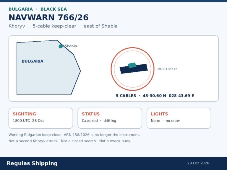
The hydrographic text is short and is the working primary. BLACK SEA. ROMANIA. PARTIALLY SUNKEN VESSEL. Cancels ARN 156/2026. Published 27 October 2026. The report clock is 27 October 2026 at 10:00 UTC, 12:00 local. The position is 43-49.502 N, 028-53.368 E in the header and 43-49,50 N 028-53,37 E in the body. The hull is named M/V KHORYV. The vessel remains afloat, capsized. Three crew members are reported missing. Ships nearby and ships transiting are to keep a sharp lookout. The keep-clear is at least one nautical mile. Report to MRCC Constanta, VHF 16 or [email protected]. That is the product. The Directorate did not print a wreck buoy, a light, a sinking time, a pollution line, a cargo, a bunker figure, an IMO number, or an attacker. It did not close the three-missing count. It did not mark the hull on the bottom.
The move is the operator fact Sunday’s keep-clear could not yet give. Friday’s first plot, 44-06.59 N, 029-01.10 E, sat on the 13-mile Constanta offset. Sunday’s plot, 43-55.25 N, 028-57.40 E, already sat about 11 nautical miles south and about three nautical miles west of that first position. Tuesday’s working plot, 43-49.50 N, 028-53.37 E, sits about 17 nautical miles south and about six nautical miles west of Friday’s capsize — a south-southwest drift of roughly 18 nautical miles over four days. From Sunday’s 155/2026 circle the hull has made good about six nautical miles south and about three nautical miles west in about 49 hours. The 04:18 UTC intermediate, ARN 156/2026 at 43-51.24 N, 028-54.54 E, already had the hull about four nautical miles south-southwest of Sunday’s plot; 158/2026 is a further two-nautical-mile south-southwest shift in under six hours, not a teleport and not a second casualty. A one-nautical-mile keep-clear around the new position is a new plotted circle. The old 43-55.25 N circle is no longer the working instrument. Constanta, Midia and Mangalia are not closed by this notice. The Sulina approaches are not closed by this notice. Do not brief a Romanian port shutdown from a drifting, still-afloat inverted hull.
The missing-crew line is still open. Friday’s Authority count was nine alive, one dead, three missing. Saturday’s first wreck notice repeated the three-missing figure. Sunday’s 155/2026 repeated it. Tuesday’s 156/2026 repeated it. Tuesday afternoon’s 158/2026 repeats it again and still asks every transiting hull to keep a lookout. It does not close the search. It does not revise the dead or the recovered. Hold Romania’s 13 and three-missing on this product. Do not invent a revised casualty table from a position update.
What this is not, and the same-week hydrographic colour
President Nicușor Dan’s Friday drone attribution, and the Reuters NATO-flank charge, stay on Friday’s dedicated Authority piece. Tuesday’s wreck-move notice does not repeat a drone, a state of origin, or a NATO tasking. Defence minister Ștefan Radu Oprea’s Friday explanation — Coast Guard first because the hit sat outside territorial waters — is still the response geometry. A hull that has drifted south-southwest toward the recommended landfall does not, by itself, move the army’s territorial-waters window. Tuesday 21 October’s dedicated NATO extra-patrol-aircraft note and Thursday’s dedicated European Parliament / Romania CSAT file remain the last alliance and EU prints on this desk. Do not sell Tuesday’s new lat-long as Black Sea Sentry, as an escort, or as a Joint War Committee circle change.
Open-register colour, already used on Friday’s dedicated file and still not an Authority or Directorate finding: IMO 8138712, Comoros, call sign D6A3168, MMSI 620999164, built 1983, about 119 metres, summer deadweight about 3,280 tonnes, ore/oil carrier on the registers. Voyage colour, also not a cargo declaration: last port Eregli on 21 October, AIS destination SVLINA, ETA 23 October 23:00 UTC. Sofia Globe’s ferrous-metals line remains media colour. The wreck-move notice names the hull and the new position. It does not confirm the cargo, the bunkers, or a pollution volume. Do not invent a slick from a drifted keep-clear. Do not recycle Wine Trader’s fire-and-abandon position, 45-00.40 N 029-59.92 E on ARN 145/2026, onto this Constanta-south offset.
Same-week Directorate colour, for the bridge folder, not as a second dedicated casualty. ARN 157/2026, also published 27 October, warns of a maritime exercise from 28 October to 3 November inside a circular area of 20 nautical miles radius centred on 44-02.79 N, 030-35.25 E, mariners to avoid entering, cancel 032130 UTC on 3 November. That box sits around the Neptun Alpha production-platform offset, well east of Tuesday’s wreck. It is not Khoryv and it is not a wreck buoy. ARN 150/2026 still warns of hydrographic survey and oceanographic research by the hydrographic vessel Căpitan Comandor Alexandru Cătuneanu on 27 and 28 October between 06:00 UTC and 15:00 UTC in a polygon west of Constanta, cancel 281600 UTC. That is a survey box, not this hull. ARN 147/2026 warns of real firing on 29 October from 14:00 UTC to 17:00 UTC and on 30 October from 07:00 UTC to 17:00 UTC in a prohibited box north of Constanta, cancel 301800 UTC. ARN 143/2026 still carries real firing and UAV flight activity through 29 October in the same northern box. Do not brief the wreck as inside those firing boxes. ARN 151/2026, the separate drifting object at 43-53.20 N, 030-43.20 E, already self-cancelled at 261100 UTC on 26 October. Coastal-protection works still sit inshore near 43-49 N, 028-37 E until 30 October; a missing port-hand light buoy remains at 43-48.17 N, 028-33.72 E. Those are harbour-approach colour. They are not this wreck. Wine Trader remains the 15 October fire-and-unmanned notice at 45-00.40 N 029-59.92 E.
Operational implications
A named, still-afloat capsized hull that has moved about 18 nautical miles south-southwest in four days is a collision, MOB and SAR-traffic problem before it is a war-risk rewrite. Sunday’s dedicated keep-clear told masters to plot 43-55.25 N, 028-57.40 E. Tuesday’s notice tells them that circle is stale. The working waypoint is now 43-49.50 N, 028-53.37 E, still one nautical mile, still three missing, still no wreck buoy and still no light. Later Friday imagery, already on the dedicated Authority file, showed only a sliver of hull above the water. The hydrographic text still says the vessel remains afloat, capsized. Hold both. A barely visible inverted hull that is also drifting is a radar and visual lookout, not a charted wreck symbol until the Directorate or the Authority says so.
The drift itself is the routing change. From the 23 October capsize to the 27 October 10:00 UTC report the hull has made good about 17 nautical miles south and about six nautical miles west. That track is toward the recommended landfall and the Constanta traffic-separation scheme, not toward Sulina and not into Tuesday’s 20-mile exercise circle around 44-02.79 N, 030-35.25 E. The Directorate’s standing recommended-routes notice still tells ships approaching and leaving Romanian harbours to use 43-47.59 N, 028-50.86 E. Tuesday’s wreck plot sits about two and a half nautical miles north-northeast of that landfall waypoint. A one-nautical-mile keep-clear around 43-49.50 N, 028-53.37 E therefore sits on the coastal-approach geometry, not 13 miles offshore where Friday’s casualty sat. Masters inbound to Constanta, Midia or Mangalia, and masters running recommended track 2 into the Constanta TSS, now have a moving obstruction near the landfall rather than a fixed 13-mile offset. A one-mile keep-clear around a hull that has already moved five times in four days will be wrong again if a later ARN reprints the position. Plot the 158/2026 circle, keep a lookout up-drift and down-drift, and expect the next numbered notice to move it again. Do not leave Sunday’s 43-55.25 N waypoint as the only wreck in the folder.
Charterers who still treat the Romanian coast as a quiet alternative to Ukrainian ports now have a drifted obstruction near the Constanta landfall and an open MOB watch. War-risk underwriters will ask for the 43-49.50 N, 028-53.37 E position, the cancelled 156/2026 intermediate, the cancelled 155/2026 Sunday plot, the still-afloat line, and the still-open three-missing count. They will not be answered by Friday morning’s Authority statement alone, and they will not be answered by Sunday’s keep-clear. Port State, flag and next-of-kin work remain with Comoros, the Ukrainian and Azerbaijani missions, and whoever holds the DOC. None of those names is on the wreck-move notice.
A pollution watch remains open because the notice is still silent. Friday’s dedicated file already told operators not to invent a spill. Saturday’s notice printed no hydrocarbon line. Sunday’s notice still printed no hydrocarbon line. Tuesday’s 156/2026 and 158/2026 still print no hydrocarbon line, no boom, and no closed beach. That is not a clean bill. Small combo / ore-oil hulls carry fuel. A hull that remains afloat and inverted after four days of drift can still release. Masters inbound to Constanta, Midia or Mangalia should expect SAR and Coast Guard traffic, a one-mile keep-clear around a new position close to the recommended landfall, and a lookout for persons in the water, not a completed wreck-removal order. Do not treat the canal, the roadstead or the port as closed unless the Authority or the harbour master says so.
What Operators Should Note
- Log a moved wreck, not a second Khoryv attack. Directorate ARN 158/2026, published 27 October, cancels ARN 156/2026. Report clock 10:00 UTC / 12:00 local 27 October. Position 43-49.50 N, 028-53.37 E (header 43-49.502 N, 028-53.368 E). Hull named M/V KHORYV. Remains afloat, capsized. Three missing. One-nautical-mile keep-clear. Report to MRCC Constanta, VHF 16 or [email protected]. Sunday’s dedicated 155/2026 keep-clear at 43-55.25 N, 028-57.40 E is no longer the working instrument. The 04:18 UTC intermediate, ARN 156/2026 at 43-51.24 N, 028-54.54 E, is cancelled. This is not Wine Trader, not Saturday’s territorial-waters Geran intercept, and not the EP / CSAT vote.
- Plot the new circle against the recommended landfall. The hull has made good about 17 nautical miles south and about six nautical miles west of Friday’s capsize, and about six nautical miles south-southwest of Sunday’s 155/2026 plot. The working keep-clear now sits about 2.6 nautical miles from the standing 43-47.59 N, 028-50.86 E landfall waypoint used for Constanta TSS entry. Constanta, Midia, Mangalia and the Sulina Canal are not closed by this notice. Keep at least one nautical mile from the new position. Keep a lookout up-drift and down-drift. Do not assume the wreck is lit, buoyed or on the bottom.
- Hold Friday’s crew table. Do not invent a new one. Authority: crew 13, ten Ukrainian, three Azerbaijani, nine alive, one dead, three missing. ARN 158/2026 repeats three missing and does not revise the dead or the recovered. Do not close the search from a position update.
- Keep presidential attribution and open-register colour off this notice. President Dan’s drone and Russia-escalation line stay on Friday’s dedicated Authority piece. IMO 8138712, ore/oil, 1983, about 3,280 dwt, Eregli–Sulina AIS colour and ferrous-metals media colour stay as they were. The wreck-move notice names the hull and the new position only. No cargo, no bunkers, no pollution volume, no attacker.
- Do not merge Tuesday’s other ARN products onto this hull. ARN 157/2026 is a 20-nautical-mile maritime-exercise circle centred on 44-02.79 N, 030-35.25 E from 28 October to 3 November, cancel 032130 UTC 3 November — Neptun Alpha offset, not this wreck. ARN 150/2026 remains the 27–28 October Cătuneanu survey polygon, cancel 281600 UTC. ARN 147/2026 and ARN 143/2026 remain the northern firing / UAV boxes through 29–30 October. ARN 151/2026 already cancelled at 261100 UTC 26 October. Wine Trader remains ARN 145/2026 at 45-00.40 N 029-59.92 E. Keep each on its own sheet.
- Leave NATO, EP and Friday’s casualty file where they are. Tuesday 21 October’s extra patrol-aircraft note remains the last alliance print. Thursday’s EP 432-52-88 / CSAT file remains a consider-operation vote plus a coastal-state capability order. Friday’s Authority naming remains the casualty and search piece. Saturday’s first keep-clear remains the first public lat-long. Sunday’s 155/2026 remains the previous working circle. Watch a later ARN that moves 43-49.50 N, 028-53.37 E again, marks a wreck buoy, prints pollution, or closes the three missing — not a completed sinking and not a Black Sea escort.
Regulas Shipping will keep lining Tuesday’s ARN 158/2026 position at 43-49.50 N, 028-53.37 E against Sunday’s 155/2026 keep-clear and Friday’s Authority naming of Khoryv so operators can treat the Constanta landfall offset as a drifted, still-afloat wreck and an open MOB watch, not as a second attack or a closed search.