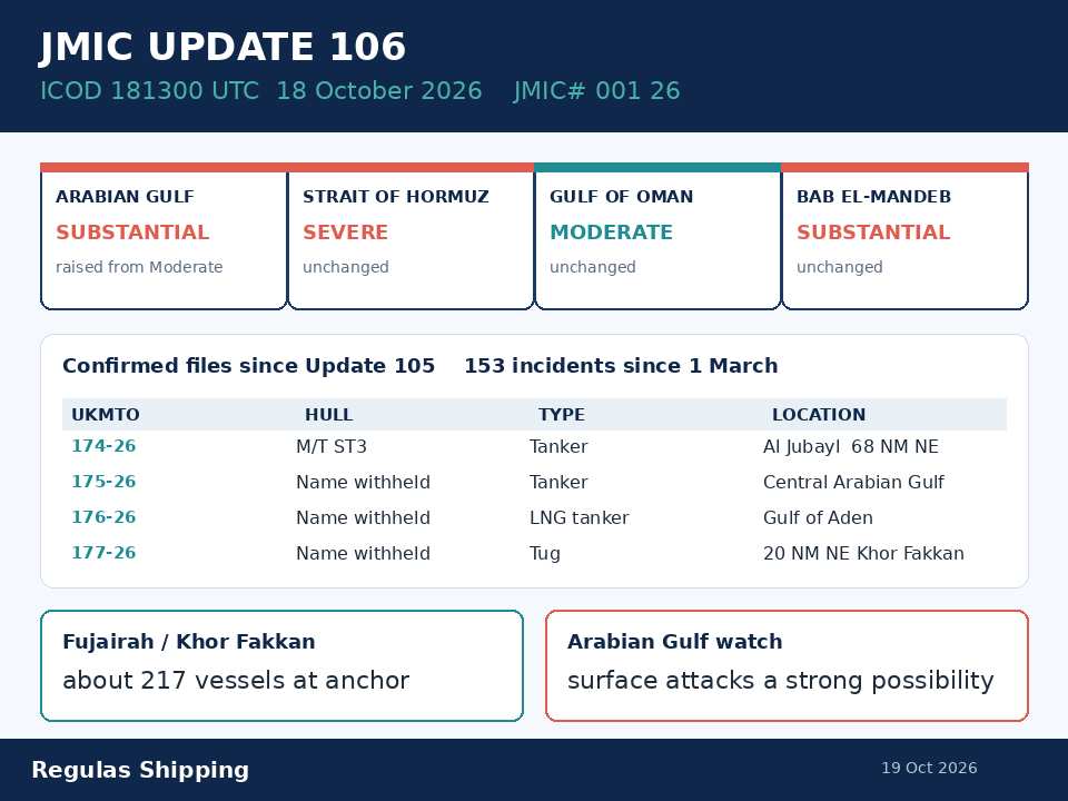
The U.S. Navy-led Joint Maritime Information Center published Update 106 to its regional advisory note with an information cut-off of 181300 UTC on 18 October. The note, JMIC# 001 26, is the first numbered public update since Update 105 of 15 October. Hormuz remains at SEVERE. The Arabian Gulf is raised from MODERATE to SUBSTANTIAL. The Gulf of Oman stays MODERATE, and Bab el-Mandeb / the southern Red Sea stays SUBSTANTIAL. Confirmed vessel incidents since 1 March are now printed as 153, up from 149 on Update 105. The confirmed-incidents table adds four files since the last report: UKMTO 174-26 through 177-26. One of those hulls is named. 174-26 is M/T ST3. 175-26, 176-26 and 177-26 remain “Name withheld UFN.”
That is the working primary. Sunday’s note is a numbered regional instrument, not a Hormuz reopen, not a rewrite of the dedicated UKMTO 174-26 through 177-26 pieces, and not a rewrite of Friday’s dedicated India-ministry naming of ST 3. It is also not the International Maritime Organization’s highlighted-incidents board, which is still printed as 113 confirmed incidents as at 14 October. Those are different counters. The useful facts for a DPA and a bridge team are the Arabian Gulf upgrade, the first JMIC naming of ST 3 against Warning 174-26 at 68 nautical miles northeast of Al Jubayl, the still-unnamed 175-26 / 176-26 / 177-26 rows, the Fujairah / Khor Fakkan congestion print of about 217 hulls, the standing Pride wreck caution, and the outlook that now treats surface attacks in the central Arabian Gulf as a strong possibility away from the Strait. Do not treat industry matching or the original unnamed UKMTO PDFs as a substitute for this numbered note, and do not treat Update 105 as still the current threat scale for the Arabian Gulf.
What Update 106 actually added
Update 105’s information cut-off was 151300 UTC on 15 October. It already carried 165-26 through 173-26, named Petro Dolphin, Al Maqam, DP World Kaveri, Kition M, Ever Vict, GFS Pride, GFS Giselle and Al Saadiyat, and left 171-26 unnamed. Update 106 does not reprint that table and does not downgrade Hormuz. It adds the next four products that had cleared confirmation by 181300 UTC on 18 October, and it is the first numbered JMIC note to raise the Arabian Gulf.
On 174-26, Update 106 names M/T ST3. That is the first JMIC naming of the hull that sat as Friday’s dedicated India-ministry piece and as Saturday’s dedicated unnamed Warning 174-26. The numbered note places the tanker in the central Arabian Gulf. UKMTO received a report that on 16 October a tanker identified as the ST3 by the Indian shipping minister was struck by an unknown projectile about 68 nautical miles northeast of Al Jubayl, Saudi Arabia. All crew reported safe and evacuated. No environmental impact reported. Friday’s dedicated ministry piece printed a Hormuz geometry and did not print a UKMTO number. Saturday’s dedicated 174-26 piece remained an unnamed tanker Attack 68 nautical miles northeast of Al Jubayl. Update 106 is the instrument that puts those two files on the same named row. It does not print an IMO number, a cargo grade, a fire line, a wreck, a return-aboard, or an attacker. Open-register colour only, already used on this desk: do not treat the naming as a completed damage survey, a UKMTO PDF naming, or a rewrite of either dedicated piece. Stay with JMIC’s Jubayl offset on this note. Do not collapse Friday’s Hormuz ministry line into a completed correction; hold both clocks until a flag, class or a later numbered note closes the geography.
On 175-26, Update 106 still withholds the name. A tanker in the central Arabian Gulf was attacked on 16 October after being approached by a small boat, resulting in damage to the aft port quarter. All crew accounted for and reported safe. Full damage assessment and environmental impact unknown. The dedicated 17 October 11:30 Warning 175-26 piece remains the original RPG / small-boat Attack product 78 nautical miles northeast of Al Jubayl. Update 106 does not print RPG, a hull, a flag, a heading or a pollution volume. Keep the two numbered files. Reuters and Arab News on Saturday could not establish whether 174-26 and 175-26 were the same incident. JMIC prints them as two rows. Do not merge them.
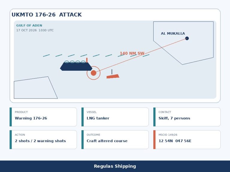
On 176-26, Update 106 still withholds the name. An LNG tanker in the Gulf of Aden was approached on 17 October by a skiff with seven persons on board about 140 nautical miles southeast of Al Mukalla, Yemen. The skiff fired two shots. The embarked armed security team fired two warning shots and the skiff altered course. The dedicated 18 October 03:30 Warning 176-26 piece remains the original ATTACK product. That PDF and UKMTO’s recent-incidents board print southwest of Al Mukalla. Hold both bearings on the same unnamed file. MSCIO Alert 149/26 remains Saturday’s parallel Suspicious Activity product at approximately 12°54′N 047°56′E. NAVAREA IX 383/26, issued 17 October, prints an attempt of piracy at 12-54.00N 047-55.00E and advises mariners to keep clear and exercise extreme caution; the message cancels at 232359 UTC on 23 October. Update 106 cites that NAVAREA as attempted piracy. Do not collapse an ATTACK warning into a Suspicious Activity alert, and do not brief the NAVAREA as a hull naming.
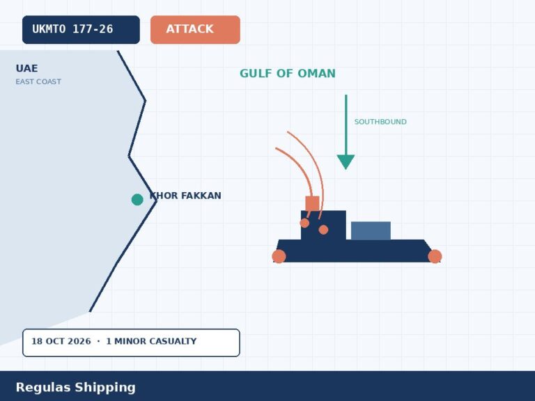
On 177-26, Update 106 still withholds the name. A tug travelling south 20 nautical miles northeast of Khor Fakkan reported being struck by two unknown projectiles on 18 October. The vessel sustained damage but continued its route. One minor crew injury has been reported. The dedicated 18 October 11:30 Warning 177-26 piece remains the original unnamed tug Attack. UKMTO’s PDF printed neither the 20-nautical-mile offset nor a Strait of Hormuz TSS box; it printed northeast of Khor Fakkan, United Arab Emirates. Update 106’s table labels the location “Strait of Hormuz” and the narrative keeps the Khor Fakkan offset. Hold both. This desk’s dedicated 177-26 piece treated Sunday as a United Arab Emirates east-coast / western Gulf of Oman file, not a Hormuz traffic-separation-scheme file. Do not recast the numbered note as a TSS increment or as a hull naming.
What sits off the list, and the traffic that moved
Sunday’s cut-off is 181300 UTC on 18 October. UKMTO still has no 178-26 or later product on the public warnings board used for this desk. Update 106 does not print a new Bab el-Mandeb Attack, a named Pride wreck survey, or an IMO-board move off 113. 171-26 remains unnamed on Update 105’s table; Update 106 does not reopen it. Angola Prosperity remains off this table.
The Arabian Gulf operational summary is the paragraph that should replace Update 105’s version in the master’s pack. Two attacks were reported to UKMTO in this period, both in the central Arabian Gulf off Al Jubayl (174-26 and 175-26). NAVAREA IX 382/26 reported a lifeboat adrift at 27-46.90N 050-36.00E; that message was written to cancel at 182359 UTC on 18 October. Traffic flows continued, with anchorage congestion high across the region. Navigational-system interference rose on 16 October across the central and southern Arabian Gulf, from the Kuwait / north-east Saudi coast via Bahrain and Qatar to Abu Dhabi – Dubai. The outlook is plainer than the last note: the two Jubayl tanker attacks show that attacks, including surface attacks, remain a strong possibility in the central Arabian Gulf, away from the Strait of Hormuz. GNSS interference is expected to remain elevated in the western Gulf. That is a routing change. It is not a port closure.
The Strait of Hormuz summary carries one new Attack in the period, 177-26, against UKMTO’s weekly overview of 16 October, which recorded 12 attacks in the week and assessed further attacks as highly likely. NAVAREA IX 373/26 remains active for the GFS Pride wreck and floating containers. On 17 October the IRGC Navy claimed that two supertankers had struck mines in the Strait of Hormuz; Update 106 prints “there is no substantiation to these claims.” Stay with that. IRGC attacks, attempted attacks and harassment persisted, including UAV overflight, targeted surveillance and occasional VHF hailing. Commercial traffic through the Strait remained at reduced levels against the 2025 baseline. Independent tracking still indicated single-digit transits. U.S. NCAGS data indicated U.S.-assisted flows averaging about 28 vessel transits a day for the last 72 hours. UKMTO’s weekly overview recorded 254 transits (125 outbound, 129 inbound) in the week to 14 October, about 70 percent below pre-conflict levels. U.S.-facilitated Strait of Hormuz transits for 15–18 October, the past 72 hours, are printed as 83. Do not add the 83, the 28-a-day series and the independent single-digit series into one throughput figure.
Cape Dao is the increment that cuts against Wednesday’s IMO-board piece and against Update 105 rather than repeating them. The Gulf of Oman summary says no new attack or disruption was reported in this period. NAVAREA IX 380/26, dated 16 October, reported that the bulk carrier CAPE DAO (UKMTO 142-26) was sinking and drifting eastward about 33 nautical miles northeast of Port Al Suwaiq, cancelling NAVAREA IX 370/26; “she has not sunk.” Update 105 had already printed the status as disputed, not sunk. Wednesday’s IMO 113-count still carried a Sunk line. Hold all three instruments. Do not brief a completed wreck survey. Do not merge Cape Dao with GFS Pride.
Blockade hygiene moved by three redirected hulls and not by a fifth disablement. The latest official CENTCOM figures cited in Update 106, dated 17 October, are 138 commercial vessels redirected; four vessels had been disabled as of 10–11 October during blockade enforcement. Update 105’s 10–11 October line was 135 redirected and four disabled. No further CENTCOM blockade-enforcement action was announced in this period. Neutral transit remains permitted. Visit-and-search, a 30-nautical-mile standoff from U.S. units, AIS-on unless constrained by security threats, continuous monitoring of VHF Channel 16, and a humanitarian-cargo exemption via NAVCENT NCAGS are still the published tools. Approved humanitarian vessels may transit to Iranian ports but remain subject to inspection and may not load cargo in Iran beyond fuel and stores.
Port and anchorage congestion is printed as of 18 October and is the other operator paragraph. About 217 vessels were at anchor in the vicinity of Fujairah / Khor Fakkan, the highest in the reporting period, up 21 percent over 72 hours, with Fujairah itself moving from 126 to 159. About 166 were off Dubai / Jebel Ali to Ras Al Khaimah, unchanged over 72 hours. About 56 were in the vicinity of Musandam / Sohar. About 35 were stationary off Bandar Abbas / Qeshm. Holding continues to shift to the Gulf of Oman side. Update 106’s own line is that the 18 October attack on a tug northeast of Khor Fakkan shows this concentration remains exposed to attack despite its location outside the Strait. GNSS interference in the Arabian Gulf eased on 17 October after the 16 October surge and is assessed elevated, now concentrated in the western Gulf from Dammam via Jubail to Khafji, Bahrain and Kuwait offshore. The Strait of Hormuz and the Gulf of Oman remained at the established high baseline. UKMTO’s weekly overview for the week ending 16 October recorded 23,166 anomalous AIS positions over seven days, against 18,881 the week before, and eight vessel GNSS reports. No new specific UKMTO, MARAD, NAVCENT or NAVAREA IX GNSS/EMI notices were issued 15–18 October. Baseline advisories remain in force.
The Gulf of Aden summary carries 176-26 and nothing else new in the 72-hour window. Commercial traffic remained relatively steady. The 24–48-hour outlook is the monsoon line: the southwest monsoon has withdrawn, forecast maximum wave heights in the Gulf of Aden are 0.4–0.8 metres, and skiff operations, including those launched from dhow or hijacked fishing-vessel mother ships, are therefore likely to become more feasible across the Gulf of Aden and the IRTC. MT ASANA, the Tanzanian-flag product/chemical tanker hijacked on 17 July about 65 nautical miles southwest of Mukalla, is still the one merchant vessel remaining hijacked. Southern Red Sea / Bab el-Mandeb stays SUBSTANTIAL, with traffic below the 20 July Houthi selective embargo. Bab el-Mandeb cargo transits for 15–18 October, the past 72 hours, are printed as 99 against a 2023 baseline of about 61 vessels a day. On 16 October Saudi Arabia’s Ministry of Defence reported intercepting a ballistic missile targeting Yanbu and two cruise missiles over the Red Sea. Ship loadings have resumed at Yanbu after strikes on the East–West Pipeline on 10–11 September. Suez remains functional both ways. Eastern Mediterranean stays LOW.
Operational implications
A numbered JMIC update is a routing and manning problem before it is a count of who was hit. Hormuz is still SEVERE, with deliberate attacks called highly likely, AIS-on targeting risk, directed hails toward the northern Iranian-controlled route, and a specific watch for attempted mining within and adjacent to the traffic-separation scheme. That guidance did not move because ST 3 was named. What moved is the Arabian Gulf column, from MODERATE to SUBSTANTIAL, on the back of two confirmed tanker Attacks off Al Jubayl on 16 October, one of them a small-boat / aft-quarter file, and a GNSS surge that has since concentrated in the western Gulf. An attack in the central Arabian Gulf is now printed as a strong possibility, including surface attacks, away from the Strait. Masters who still brief the Gulf as Update 105’s MODERATE basin will have the wrong scale on the chart.
The anchorage paragraph is the line that should sit next to the 217-hull Fujairah / Khor Fakkan print. Vessels stationary for extended periods, or maintaining AIS-on while static, may face elevated targeting risk. Update 106 encourages, subject to the master’s judgment, port / VTS coordination, traffic and reliable navigation: maintain movement and avoid predictable operating patterns where practicable; consider periodic repositioning within anchorages; maintain regular reporting contact with UKMTO irrespective of AIS transmission status; and review AIS transmission policies within established risk-management frameworks while remaining compliant with SOLAS. That is not a published order to go AIS-off. It is not a closure of Fujairah. It is a congestion-plus-projectile watch on the Gulf of Oman side, written after 177-26 hit a tug 20 nautical miles northeast of Khor Fakkan. Harbour assists, wreck response and disabled-hull tows operating in that density are in the same watch as shuttle tankers.
The ST 3 row is a briefing-discipline problem, not a new casualty. Friday’s dedicated ministry piece named the hull against a Hormuz projectile and printed 15 Indian seafarers safe. Saturday’s dedicated 174-26 piece printed an unnamed tanker Attack 68 nautical miles northeast of Al Jubayl, crew evacuated, no reported environmental impact. Update 106 is the first numbered JMIC note that puts ST 3 on 174-26 at that Jubayl offset. It does not convert Friday’s Hormuz line into a completed flag-state finding, and it does not print a fire, a wreck or a pollution volume. A master’s pack that briefs “JMIC moved ST 3 into Hormuz” has over-read the table. A pack that briefs 174-26 and 175-26 as one hull has over-read the two-row layout. Stay with two numbered files, one named, one withheld, both in the central Arabian Gulf on this note.
The IRGC mine claim is the same briefing-discipline problem it was on Update 105. Update 106 prints no substantiation on the 17 October two-supertanker claim. The same note still tells mariners to remain vigilant for attempted mining within and adjacent to the TSS. Those two sentences can sit together. A master’s pack that briefs “JMIC ruled out mines” has over-read the unsubstantiated-claim line. A pack that briefs a confirmed mine on an unnamed Sunday hull has over-read the IRGC statement. Stay with unknown projectiles on 174-26 and 177-26, an RPG/small-boat line only on the dedicated 175-26 PDF, no substantiation on the mine claim, and a standing mining watch.
CSOs should replace the 15 October Update 105 pack with Update 106 in the master’s folder and in the charterer’s security clause file. The new named line is ST 3 on 174-26. The still-unnamed lines are 175-26, 176-26 and 177-26. The new scale line is Arabian Gulf SUBSTANTIAL. The new congestion line is about 217 hulls in the vicinity of Fujairah / Khor Fakkan as of 18 October. The new NAVAREA lines are 380/26 on Cape Dao, 382/26 on the northern-Gulf lifeboat, and 383/26 on the Gulf of Aden attempted-piracy box through 232359 UTC on 23 October. None of those edits is a flag circular, a class condition, or a completed MARPOL finding. Do not replace the dedicated UKMTO PDFs, Friday’s dedicated ST 3 ministry note, Saturday’s dedicated 176-26 / 177-26 pieces, or Wednesday’s IMO 113-count. They are different instruments. Update 106 is the numbered regional threat note that now sits on top of them.
Do not recast Sunday as a UKMTO naming in the original PDFs, as a Hormuz reopen, as a completed Cape Dao wreck survey, as a rewrite of Warning 174-26 through 177-26, as a rewrite of Friday’s India-ministry piece, or as a substitute for the IMO 113-count. IMO’s 113 and JMIC’s 153 are different datasets. Masters who brief Sunday as Update 105 still in force, or as UKMTO finally printing ST 3 on the 174-26 PDF, will have misread the instrument.
What Operators Should Note
- Log Update 106, ICOD 181300 UTC 18 October, not a Hormuz downgrade. JMIC# 001 26. Hormuz SEVERE. Arabian Gulf SUBSTANTIAL, raised from MODERATE. Gulf of Oman MODERATE. Bab el-Mandeb / southern Red Sea SUBSTANTIAL. Gulf of Aden SUBSTANTIAL. 153 incidents since 1 March, four since Update 105. Replace Update 105 in the master’s pack. Do not confuse this numbered note with the IMO highlighted-incidents board’s count of 113 as at 14 October.
- Name only the hull JMIC named, against the product it named. 174-26 M/T ST3, central Arabian Gulf, 16 October, unknown projectile about 68 nautical miles northeast of Al Jubayl, all crew safe and evacuated, no environmental impact reported. That is the first JMIC naming. It is not a rewrite of Friday’s dedicated India-ministry Hormuz piece and not a retroactive edit of Saturday’s unnamed 174-26 PDF. Hold Friday’s Hormuz ministry geometry beside Sunday’s Jubayl JMIC row until a flag, class or a later numbered note closes the geography. Do not invent an IMO number, a fire or a wreck.
- Keep 175-26, 176-26 and 177-26 unnamed. 175-26 remains a 16 October central-Arabian-Gulf tanker, small-boat approach, aft port quarter damage, crew safe, damage and environment unknown; the dedicated PDF’s RPG line stays on that PDF. 176-26 remains an unnamed LNG, 17 October, 140 nautical miles off Al Mukalla; hold JMIC’s southeast bearing against the dedicated PDF’s southwest bearing; keep MSCIO Alert 149/26 and NAVAREA IX 383/26 (12-54.00N 047-55.00E, cancel 232359 UTC 23 October) beside it. 177-26 remains an unnamed southbound tug, 18 October, 20 nautical miles northeast of Khor Fakkan, two unknown projectiles, damage, continuing, one minor casualty; hold JMIC’s “Strait of Hormuz” table label against the dedicated Khor Fakkan / western Gulf of Oman file. Do not merge 174-26 and 175-26.
- Treat the Arabian Gulf upgrade and the Fujairah density as live routing, not as a published closure. SUBSTANTIAL means an attack is a strong possibility, including surface attacks off Al Jubayl, away from Hormuz. About 217 vessels were at anchor IVO Fujairah / Khor Fakkan as of 18 October, Fujairah itself 126 to 159 in 72 hours, about 166 Dubai / Jebel Ali to Ras Al Khaimah, about 56 Musandam / Sohar. 177-26 shows that density is exposed outside the Strait. Periodic repositioning, UKMTO reporting irrespective of AIS status, and a SOLAS-compliant AIS review are the printed mitigations. AIS-off is not a detection shield and is not an order on this note.
- Do not add Sunday’s traffic and blockade numbers into one throughput figure. NCAGS about 28 transits a day over 72 hours. U.S.-facilitated Hormuz transits 15–18 October: 83. Independent series still single-digit each way. UKMTO weekly to 14 October: 254 transits, about 70 percent below pre-conflict. BAM cargo transits 15–18 October: 99. CENTCOM 17 October blockade line is 138 redirected; four disabled remains the 10–11 October figure. NAVAREA IX 373/26 remains the Pride wreck / floating-container caution. NAVAREA IX 380/26 keeps Cape Dao as sinking/drifting, not sunk, cancelling 370/26. NAVAREA IX 382/26’s northern-Gulf lifeboat cancelled at 182359 UTC 18 October. Asana is still hijacked. Yanbu loadings have resumed; the 16 October ballistic-missile intercept is a terminal-range line, not a canal closure.
- Keep the mining watch and drop the unsubstantiated two-tanker claim. Update 106 prints no substantiation on the 17 October IRGC Navy claim that two supertankers struck mines in the Strait. The same note still flags attempted mining within and adjacent to the TSS, AIS-on targeting risk, and directed hails toward the northern Iranian-controlled route. The 30-nautical-mile standoff from U.S. units and the NCAGS humanitarian exemption are still blockade procedure. GNSS remains elevated in the western Gulf; UKMTO’s week to 16 October printed 23,166 anomalous AIS positions. Cross-check with radar and visual navigation. Watch the next numbered warning, Update 107, or an IMO-board move off 113 — not a Hormuz reopen.
Regulas Shipping will keep lining Update 106’s 181300 UTC cut-off against UKMTO 174-26 through 177-26 so operators can treat Sunday’s Arabian Gulf upgrade, the ST 3 naming on 174-26 and the 217-hull Fujairah watch as a live routing pack, not as a Hormuz reopen or a retroactive naming of the original UKMTO PDFs.